Showing posts with label nature. Show all posts

Wednesday, February 11, 2015

The Birth of the Pulaski and the Great Fire of 1910

Volunteer Ed Leonard sharpens his Pulaski on a WV trip in Dolly Sods 2012
If you've been on a service project with WV, there is a very good chance you've used a Pulaski. This common hand-tool features an ax on one side of the head and an adze or hoe on the other. The Pulaski is the preferred tool of choice in fighting wildfires and building trail, among many other outdoor uses. But do you know the circumstances of how it was invented?

Last week the television series American Experience, which airs on PBS stations across the country, featured an in-depth documentary on the massive fire of 1910 in the northern Rockies, The Big Burn. Still unsurpassed in American history, this gigantic blaze burned more than 3 million acres and over 100 lives were lost in a weekend. The documentary details the impact this fire would have on the burgeoning National Forest Service and the tenuous political climate surrounding Gifford Pinchot and the agency's growth under President Theodore Roosevelt. Also detailed in the documentary is the valiant efforts and particular history of one assistant ranger in Idaho, Ed Pulaski.

For anyone who has swung a Pulaski and/or cares about the history of our public lands, it is a really interesting tale. Luckily, if you missed it, you can watch it below. More information is also available on the American Experience website.

Please let us know what you thought of this documentary in the comments section below.


Wednesday, November 27, 2013

Photo from the Field: Pinnacles National Park by Ulrich Boegli

To celebrate the upcoming holiday, this week's photo from the field is of wild turkeys found at Pinnacles National Park. This photo was taken by Ulrich Boegli when visiting the Park a few months in advance of the Wilderness Volunteers' service project he would join in spring 2013. These native turkeys are regularly seen and heard from the Park's campground.

While WV's 2014 service project in Pinnacles is full, opportunities remain to sign up for spring service projects in other fantastic wilderness areas around the country.


From all of us at Wilderness Volunteers, thanks for all of your efforts giving something back this year! Have a wonderful Thanksgiving!

Tuesday, November 19, 2013

Photo from the Field: Superstition Wilderness by Sarah Slover

Photo from the Field: Taken by Sarah Slover on WV's spring service project in the Superstition Wilderness of Arizona's Tonto National Forest in March 2012.

You can sign up now for WV's 2014 service project in the Superstition Wilderness, as well as many others at http://www.wildernessvolunteers.org/php/projects.php


Wednesday, October 09, 2013

2014 Spring Schedule Released


The WV 2014 Spring Schedule is out now! We will be returning to many established projects, such as our award-winning project in Yosemite National Park, as well as introducing several new service projects, including Point Reyes National Seashore in California, Utah's San Rafael Swell and Red Buttes Wilderness in Oregon.

Supporters who make a financial contribution of $35 or more to WV get the first chance to sign up for projects, as registration is limited to supporters for the month of October. If you haven't donated to Wilderness Volunteers in the last 12 months, please consider making your financial contribution today.

We look forward to giving something back with you in the field in 2014!

Thursday, September 12, 2013

WV Honored as Yosemite Volunteer Group of the Year


Wilderness Volunteers has been selected as the Volunteer Group of the Year by Yosemite National Park!

With over 9,500 volunteers donating their time and energy in Yosemite this year, it is a great honor to be chosen as the best of the year. We're grateful for the hard work of all of our volunteer participants and especially the project's leaders, Dean and Laurie Twehues. Victoria Hartman, Yosemite's Wilderness Restoration Coordinator, recognizes the group by saying, "Your work is critical to the park’s ability to protect and preserve our rich natural and cultural heritage while providing meaningful and enjoyable experiences for our visitors." All participants will be receiving a thank you gift from the Park as part of the award.

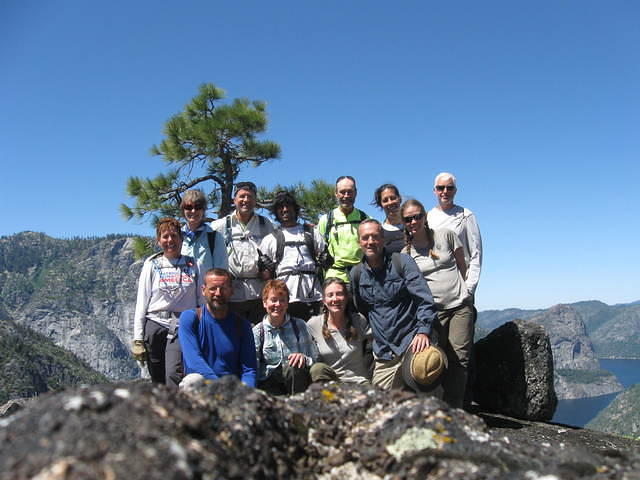
The award-winning WV Yosemite volunteers, June 2013. Photo by Dean Twehues
We just completed the 6th project in the Rancheria Falls area, in the Hetch Hetchy section of the Park. Our work includes removing and ecologically restoring inappropriate campsites, as well as removing non-native invasive species such as salsify, mullein and bull thistle from the Tiltill meadow, a remote high sierra valley with an abundance of wetlands and wildlife. The project requires volunteers to backpack in approximately 6.5 miles to base camp and an additional daily 6 mile roundtrip hike to get to the work site. Sadly, the Hetch Hetchy area is still being impacted by the massive Rim Fire, so we're sure our volunteer stewardship work will be greatly needed in the coming years.

Photo of Hetch Hetchy taken on the WV service project in Yosemite, June 2013 by Lawrence Herko

Dave Pacheco and Paul Goldberg of the WV staff will be on hand in Yosemite to accept the award. The award ceremony will be held on National Public Lands Day - Saturday, September 28th at 4pm in front of the Valley Visitor Center, and will be followed by a raffle and live music as part of the Park's 5-day Yosemite Facelift event. You are welcome to come celebrate with us! The 10th annual Yosemite Facelift is an effort to help clean-up the Park at the end of the busy summer season and runs from September 24 - 29.

Volunteers working in Yosemite, June 2013. Photo by George Ralston

See more photos from this project and more via the WV photo gallery.

Wednesday, August 28, 2013

Coming Back For More


We received this nice note from Glenn Thornton, a participant on WV's service project in Utah's Dark Canyon Wilderness of the Manti-La Sal National Forest, May 12 - 18, 2013.


Dave and Wilderness Volunteers,

Glenn conquering invasive tamarisk
Thanks for the fantastic opportunity to "give something back" on the 2013 service project in Dark Canyon. It truly was a rich and rewarding experience. This was my first WV trip and so I was not quite sure what to expect. Some volunteer/non-profit projects end up being a bit cobbled together logistics and communications wise. But with WV, I was very pleased to be able to have access to an up-to-date website with current info in the participants area, as well as the trip specific communications that were sent out to each participant. Then in the field you and Peyton had everything well planned and organized so that the hike in, and the camp-life was kept smooth and safe. And the food was quite good, varied and fresh, considering the remote location and all.

After all the hard work your crews have done in Dark Canyon and Woodenshoe Canyon, I felt honored to help WV and the USFS get one step closer to declaring victory over the evil tamarisk in Dark Canyon, at least in the wilderness portion of Dark Canyon. If all you guys offer is great volunteers, great leaders, great remote logistics, and seven days of hard and hot sandy work killing tamarisk while hiking in some of the most beautiful country around, then I'll definitely be back for more. Thanks again!

Glenn Thornton


While WV's next trip to Dark Canyon is already full, we'll likely be back in 2014. There are a just a few projects still in need of volunteers, such as a great project in the Moquith Mountain Wilderness Study Area by Kanab, UT and a neat one in the San Gabriel Mountains within the Angeles National Forest. Take a peek over on the WV project page for all the info on the service projects remaining in 2013.


Wednesday, June 26, 2013

WV Celebrates WV's 150th


We know we're not the only WV out there.  The fine state of West Virginia is celebrating their sesquicentennial this week.  It's a state that has an abundance of wild lands and that's worth celebrating!  

This fall we'll be running our third consecutive service project in West Virginia wilderness. Our trip to the Dolly Sods wilderness is all full this year (you can always join the waitlist), so be sure to sign up early when next year's schedule is released.

A photo from WV's 2012 project in Dolly Sods Wilderness
In the meantime, our friends at The Nature Conservancy have released this travel guide to help you discover some of the great natural areas you can explore in the Wild and Wonderful state. Enjoy!


Thursday, June 06, 2013

WV Receives Presidential Volunteer Service Award


We were happy to receive this award and accompanying letter from President Obama in the mail this week.  This recognition was prompted by our agency partners at the Sierra National Forest, due to our continuing service project in the John Muir Wilderness.  Space is still available to join this project in California's Sierra National Forest, applauded by the White House, which runs August 11-17.

Sierra NF's Partnership Coordinator, Chor Yang, thanked WV for our "untiring commitment and unyielding dedication." We are grateful to all WV trip participants for joining in the effort to give something back as we celebrate and sustainably steward our country's wild lands.


Monday, May 06, 2013

My First WV Project

While I’ve come to get the know Wilderness Volunteers very well over the last half year as the organization’s first Development Coordinator, it wasn’t until the recent service project in America's newest national park, Pinnacles, that I got to experience WV in the field. It was a truly wonderful experience getting out into the wild to give something back as well as meeting a terrific group of dedicated volunteers and park personnel.

The WV group at Machete Ridge in Pinnacles NP
We arrived to the Pinnacles campground on the east side of Pinnacles on a warm Sunday afternoon after a lovely drive down highway 25, known as Airline Highway supposedly because pilots used the highway as a marker on the route from LA to San Francisco. The highway has beautiful rolling hills as it parallels the San Andreas Fault, which figures into how Pinnacles came to be. The exposed rocks of Pinnacles' peaks differ from these surrounding foothills, as it is part of the remains of a massive ancient volcano that was active 23 million years ago. As part of the Pacific Ring of Fire, the volcano was 15 miles long and nearly 8,000 feet high.  Surprisingly, the volcano was located nearly 200 miles to the southeast, just north of where LA is today. Due to the earth's tectonic plates colliding and shifting, the volcano was split and two-thirds of the remains have been pushed north to where it lies now.  As the plates moved, the mass sank and erosion has carved the impressive spires that are the Park's most recognizable feature. Surprisingly, the rocks continue to move towards San Francisco at the rate of a quarter of an inch per year.
Hard to believe these rocks made a 200 mile journey to get here.
After we all arrived and set up camp, the group began to get to know each other over our first fabulous meal prepared by Carleton Sheppard. Wonderful meals would become a regular occurrence during our week at Pinnacles thanks to Carleton.  The other half of our leader team, Bill Sheppard, then gave us a brief intro on what to expect for our first workday the following morning, when we would meet with the NPS staff.
On the hunt for thistle, Photo by Ulrich Boegli

After a hearty breakfast, we were introduced to the park by NPS staff Brent, Lucy and Esperanza, who gave a great overview of the Park's features, history, conservation management goals and potential hazards to be aware of during our time in the backcountry. We were then given leather work gloves, counters, hiking poles and snake chaps as we set out to begin our week hunting for invasive plants throughout the park. Lucy and Esperanza would be our guides for the week and we began by searching from the Bear Gulch area back to campground for invasive Italian Thistle.  We scoured hillsides and walked along a wide seasonal creek bed filled with native poppies. After lunch we spread out to scour through a section of forest until one of our volunteers, John, found the mother load of thistle. We all joined together in an approx. 40' x 40' area to pull thousands of this invasive weed that has been choking out native species.

Tuesday was our free day, since there was a meeting that required attention from NPS staff and we split into groups to climb into the heart of the park via the High Peaks Trail, sadly leaving behind one of our compatriots at camp who was feeling under the weather. Despite leaving at different times and taking slightly different routes, our group met up at the Scouts Peak lookout that offered views to the west of the Salinas Valley and the Santa Lucia Mountains that lie run along the coast. We then climbed the steep and narrow section of the trail, which was exhilarating!  Yet another fabulous lunch was followed by nice views of the Balconies section of the park and then venturing down Condor Gulch trail, which gave terrific views of the rocky crags and spires. Tuesday also was the first time for confirmed sightings of one of the park's other claims to fame - home to the endangered California Condor.


Wednesday morning was the coldest of the week, reaching just above freezing.  While the cool nights
There's invasive mustard under there.
generally offered a nice respite to the hot and dry 90 degree days, this was a very chilly morning. We warmed ourselves by a nice morning fire before taking off on one of the longer hikes of our time in the park. Departing from the Old Pinnacles trailhead, we walked north of the high peaks we had climbed the day before, along the relatively level Chalone Creek - named after the indigenous people who lived in the area. All week long we saw many beautiful birds and butterflies, and this day was no exception. After reaching the entrance for the West side of the park, we went off-trail to attack the other invasive plant we would hunt during our time at Pinnacles - invasive mustard.  We found many mustard plants, some right as they were flowering, preventing the plants from reaching the bolting stage. All the while, we had terrific views of Machete Ridge. After successfully removing several thousand mustard plants, we trekked back to the eastside of the park, passing through Balconies Cave. The caves in Pinnacles are another fun feature of the Park.  They are above-ground Talus caves, formed by falling boulders and rocks trapped in steep canyons.  The caves are partially closed to protect the bat populations that make their home there and are fully closed to the public during breeding season.

Thursday was a fascinating day as we were introduced to Alacia Welch, one of the Park's Condor Biologists. Alacia led us to areas of the Park normally closed to the public.  We ventured up a steep road to a ridge where we would continue our hunt for invasive plants. Working along steep terrain, we were treated to views that few visitors to Pinnacles see.  We also watched a young condor perch in a tree nearby the NPS facility and then watched as it took flight over our heads. Their wingspan is seriously impressive. We asked Alacia every question we could think of, and weren't able to stump her. We toured the condor facility and saw how they trap and release birds, and monitor the birds through one-way mirrors.
Alacia answered every question we could think of.
The California Condor was very nearly extinct due to poaching, lead poisoning and habitat destruction - with only a population of 22 in the wild in the 80s. A controversial captive breeding program began in 1987 by the government and continues to this day. Pinnacles is an important site for monitoring the health of the population, with other important sites in Southern California, Baja and Arizona.  Those original 22 birds were given numbers #1-22 and tagged with monitors. The population has now reached more than 400, with more than 200 living in the wild.  

We also assisted Alacia by moving brush to cover exposed water lines that had recently been installed by the facility. We then continued to hunt for invasive plants and took an adventurous off-trail route down the mountain and back to the campsite.
Our group covered the line behind this way neat condor facility
Friday was our last work day, but it proved to have some of the most impressive scenery of our time at Pinnacles.  We began by traveling through the Bear Gulch caves and reaching the bear Gulch Reservoir - a man-made reservoir to be used in case of fire protection. We then ventured off-trail into backcountry canyons, searching for more invasive plants, finding both thistle and mustard, as well as hundreds of butterflies, birds and a snake or two.


My first WV service project was an absolute blast. By my estimates we pulled more than 10,000 invasive plants, covered over 30 miles of hiking and saw a terrific array of flora and fauna. My biggest takeaway, however, was how wonderful all the participants were! Our leaders, Bill and Carleton, were fantastic and kept us safe and well fed. All the volunteers were lovely folks, had a wonderful attitude and really embodied the spirit of giving something back.  I can't wait for my next WV trip!


Wednesday, February 27, 2013

Project Spotlight: Weminuche Wilderness, San Juan National Forest

Signs of a WV project, Weminuche 2012, photo by Eric Hill
This week's project spotlight narrows in on a section of the Great Divide in the Weminuche Wilderness of Southwestern Colorado and the epic 3,100 mile Continental Divide Trail that takes hikers from Mexico to Canada. Colorado is a state rich with wild lands and the Weminuche is the state's largest with 488,340 acres of protected wilderness. Lying in both the San Juan and Rio Grande National Forests, the Weminuche is high country, averaging over 10,000' in elevation, with several peaks topping 14,000' and many more over 13,000'. The area has abundant wildlife and gorgeous alpine forests and meadows. The Weminuche is home to the headwaters of dozens of streams and rivers, including the critical Rio Grande and San Juan rivers.

Our project will focus on a section of the Continental Divide Trail north of Wolf Creek Pass in the San Juan Mountains. We will work to ensure the trail is passable with general trail maintenance and proper erosion controls. Our base camp will be at 11,400' after a several mile backpack, affording a great launching point for the work as well as free time adventures.WV project leader Jeff Moorehead had the following to say about the project:

Talk about the Spur-Throated Grasshopper
with Jeff, photo by diverdewan15
Being born and raised in Durango, I initially cut my teeth backpacking in the rugged Weminuche. I first entered it at the age of 13 and I have returned many, many times on various backpacking ventures since. I have not lost my love for this area and as I grow older, it is more important than ever to get back at least once a year. In addition to the normal rationale one might have for being in a wilderness area, the notable feature of the Weminuche is its expansiveness. One truly feels embedded in the wilds of the Rockies while traveling through this region. You don't have to use your imagination to believe you are really "away from it all".

I love WV trips because everyone attending shares a love for wild places and hard work.  Hard work in a wild place brings out the best in a personality and so a WV trip can be a very human experience as well. I endeavor to keep everyone well-fed with good tasting dishes and that is one luxury afforded by the pack train support. Many of my dishes were trail tested on the Pacific Crest Trail which I hiked in 2006. After dinner, I like to discuss hot-bed environmental issues or anything really. In general, I love science discussions. I am an evolutionary biologist that especially loves the world of insects-- specifically grasshoppers and other assorted acridids. People attending the Weminuche trip can expect to hear about the prolific endemic speciation of the alpine Melanoplinae grasshoppers. I'm not sure I buy the current explanation. If that doesn't get people excited, I've been known to sneak up my Martin backpacking guitar and entertain them with songs that are usually set at much lower elevations.

WV participants take a break for a look around on a free day in the Weminuche Wilderness, WV 2012, photo by Eric Hill
North American Divides by pfly

There are many large hydrological divides in the world (the line that separates neighboring drainage basins). None, however, can match that grandeur and prominence of the Continental Divide of the Americas or simply the Great Divide. Determining whether water flows into the Atlantic of Pacific Ocean, the Great Divide stretches from northern Alaska down to southern Patagonia, mostly following the highest peaks of the impressive ranges of the Rockies and the Andes.
The scenic San Juan Mountains in the Weminuche Wilderness, WV 2012, photo by Eric Hill


Wednesday, February 20, 2013

Project Spotlight: La Sal Mountains Roadless Area

WV's 2013 project will camp nearby the stunningly beautiful Warner Lake, photo by Jeff Maurone
A view of Mt. Peale, photo by GSEC
The Wilderness Volunteers Project Spotlight next lands on the outdoor recreation haven of southeastern Utah, in the Manti-La Sal National Forest.  Towering above the town of Moab to the east lies the impressive La Sal Mountains, the second highest range in Utah. The La Sals span about 18 miles and contain 3 clusters of peaks.  The highest peak, Mt. Peale tops out at 12,721 feet above sea level. The name of the range dates to the Old Spanish Trail when the range was referred to as the Sierra La Sal or "Salt Mountains". The range remains a prominent landmark for travelers to the region, presenting a breathtaking background to the world famous slickrock Parks of Arches and Canyonlands.

The La Sal Mountains as seen from a viewing point in Arches National Park, photo by Focused Exposure
We've planned this project in coordination with Brian Murdock, the Recreation, Wilderness and Trails Manager for the National Forest in the Moab/Monticello region. In regard to this project he writes:
Not a bad place to give something back

"The trail system in the La Sal mountains provide for a wide range of trail activities and is heavily used. As a result many of the trails are in need of maintenance to reduce impacts to forest resources. Also a new trail plan will be implemented this summer to deal with an increasing amount of use and the WV project will focus on constructing some of these new trails.  

We are planning on base camping at a high elevation camp in the La Sals (either Geyser Pass at 10,500 ft or Warner Lake at 9,300 ft). The views into the surrounding desert country are phenomenal. The project will occur in areas ranging from alpine meadows, aspen and fir stands to areas above timberline and it is usually 30 degrees cooler than the surrounding desert. Participants will be hiking out each morning to the project sites from 1-2 miles and constructing/maintaining trails with provided handtools. It is likely that we will see a large variety of wildlife (deer, elk, coyotes, bears). Many peaks over 11,000  feet are accessible to climb during free time and Warner Lake also presents good fishing."
Also a great place to go for a hike!  Join us this summer in the La Sal Mountains.


Wednesday, February 13, 2013

Project Spotlight: Mallard-Larkins Pioneer Area


Lush ferns and old growth cedar forests are a wonderful feature of Mallard-Larkins Pioneer Area, photo by summitpost.org
The Wilderness Volunteers’ Project Spotlight next falls in The Gem State. Lying about 150 miles due west of Missoula, MT in the Idaho panhandle is the extraordinary Mallard-Larkins Pioneer Area. As the highlands at the convergence of major river systems, the spectacular 30,000 acre Pioneer area is the centerpiece of a larger 260,000 acre roadless area that extends between the Nez Perce-Clearwater and St. Joe’s National Forest. The area has been under consideration for wilderness designation since the Wilderness Act was passed (there was community support to protect these lands beginning in the 1950s) and is managed like a designated wilderness. Stretching west from the Bitterroot Mountain Range, the abundance of water draining into swift rivers has carved steep canyons and sustains beautiful old-growth forests as well as crystal clear lakes and streams. The roadless area has dozens of accessible subalpine lakes, including the 35 acre Heart Lake, presenting lovely recreation opportunities, especially in the warmer summer months.
Looking down at Heart Lake, photo by Craig Gehrke
Threatened Western Toad, photo by Walter Siegmund
Once home to native Chinook and Steelhead salmon that swam all the way from the Pacific, the lakes are now stocked by Idaho Fish and Game with rainbow and cutthroat trout, as well as the native bull trout and re-introduced Kokanee salmon. Moose, elk, wolves, black bear and deer thrive here, as well as one of the largest populations of Rocky Mountain goat. The area is an important habitat for threatened and endangered species as well, such as the bull trout, western toad, fisher, harlequin duck and the Coeur d’Alene Salamander that is endemic to these Northern Idaho lands.

The steep and impressive mountain range has many craggy peaks over 6,000’, and is heavily forested. A multitude of wild berries and wild flowers live amongst massive old-growth western red cedar and western white pine. The sharp elevation change allows a wide breadth of bio-diversity to exist here, with the coastal rainforest environment of the Pacific Northwest at lower elevations, while the higher elevations support subalpine meadows and forests of western hemlock and lodgepole pine.
A view from atop an Idaho Peak, photo courtesy of summitpost.org
The Nez Perce people were native to the lower elevations in the area, but it is believed they did not regularly venture to the higher elevations due to the lack of food and passage over the mountains to Montana as exist further south. While miners flocked farther south in Idaho to where gold was found, the area around Mallard Larkin wasn’t populated until the early 20th century. In response to massive forest fires of 1910, Gifford Pinchot advocated for the management of forest land to increase protection from fires, which ultimately led to the creation of the Forest Service. Hundreds of miles of trails were created to access lookouts built atop the peaks of Northern Idaho. As air travel increased and roads were built the need for a vast network of lookouts was erased. The lookouts employed enough people that their closing led to a decrease in the local population. However, the area is now seeing an increase in usage due to the excellent outdoor recreation and beautiful scenery.

Clearing the way in the nearby Selway-Bitterrot Wilderness, Clearwater NF, 2010 photo by Mike Leonard
Our service project in the Mallard Larkins Pioneer Area is general trail maintenance. We will clear brush and cut back overgrowth as we explore the area's magnificent trails. Our campsite features striking vast views of the surrounding beauty, located atop a small pass on Smith Ridge.  Learn more about the WV Service Project in the Mallard Larkins Pioneer Area. 

Wednesday, January 02, 2013

Trip Spotlight: Alta Toquima Wilderness


Below is the first installment of what we expect will be a regular weekly feature of the WV blog – a spotlight on one of the many amazing wilderness areas where Wilderness Volunters will host a project in the next year. We plan to add a bit of insight into the unique features of the land where our projects occur and why we should all treasure what our wilderness areas provide. 
~~~


WV has many new service projects in 2013 and one we’re really thrilled about is in the Alta Toquima Wilderness in Central Nevada. The 35,860 acres of the Alta Toquima Wilderness officially became part of the now over 109 million acre National Wilderness Preservation System in 1989 and is managed by the National Forest Service as part of the Humboldt-Toyiabe National Forest’s 6.3 million acres, the largest national forest in the lower 48 states.
Even amongst the grandeur and beauty of the rest of the Humboldt-Toyiabe National Forest, the Alta-Toquima Wilderness stands out as a unique and significant area for our attention. The Toquima Mountain Range includes the massive and intriguing Mount Jefferson reaching just shy of 12,000 feet. The mountain offers terrific recreation opportunities with three summits, all connected over eight miles, with overwhelming biodiversity and plentiful fresh streams that support an incredible array of wildlife, including the nearly endangered sage grouse, native trout, bighorn sheep and many more.
The mountain offers more than hiking and has piqued scientific and human interest for a long, long time. The Wilderness area takes its name of Alta Toquima from the currently highest known native village in North America. In 1978, Dr. David Thomas of the American Museum of Natural History in New York surveyed the long abandoned site, ultimately disproving many archaeologists who believed that early American hunters avoided high altitude environments as too harsh and barren to sustain life. The survey and excavations at Alta Toquima proved that from 2500 BC to 0 AD, the mountains were used intermittently by small groups of hunters who seasonally exploited mountain sheep and permanent villages were constructed after that, around 1 AD. These new large, long-term settlements at Alta Toquima represented a major shift in how ancient Americans used mountain resources, and illustrate how archaeological research continues to teach us about the past.
Photo by Sage Ross
A century prior to that discovery, this mountain range was the catalyst for a different scientific revelation.  John Muir summited Mt. Jefferson on August 17th, 1877, noting its striking qualities and confirming the theory that the Great Basin was indeed carved of glaciers:
“…while making the ascent of Mount Jefferson, the dominating mountain of the Toquima Range,  I discovered an exceedingly interesting group of moraines, cañons with V-shaped cross sections, wide névé amphitheatres, moutonnéed rocks, glacier meadows, and one glacial lake, all as fresh and telling as if the glaciers to which they belonged had scarcely vanished.
….This is a very marked and imposing mountain, attracting the eye from a great distance. It presents a smooth and gently curved outline against the sky, as viewed from the plains, and is whitened by patches of enduring snow.”
-John Muir, Eureka, NV, 1878, The Writings of John Muir, vol. 8

The mountain still maintains significant scientific interest today, recently becoming designated as a Research Natural Area by the forest service given its extreme conditions and opportunity for the study of alpine plants and wildlife.
Indeed, the Alta Toquima Wilderness offers a great deal of exciting history, knowledge and beauty.  The Wilderness Volunteers service project there will allow you to visit, experience and enjoy this amazing land while giving something back.  We’ll camp at the lovely Pine Creek campground and work on the trails to provide access to the higher elevations, plus we’ll have an opportunity to explore and play in our free time.  Learn more and sign up for the WV service project in the Alta Toquima Wilderness.
If you’ve got a favorite wilderness volunteers project you’re partial to and have info or photos to share with us, please don’t hesitate to email info@wildernessvolunteers.org.

Friday, December 07, 2012

2013 Summer/Fall Schedule Released!


Goat Rocks Wilderness, Gifford Pinchot NF (2012)
We are super excited to announce the release of the full 2013 Service Project schedule!  It is a record setting year as WV will give something back in more wilderness areas in a single year than ever before, with trips from Hawaii to Vermont, Alaska to Texas and many, many areas in between.

We'll need your help to ensure that we complete all the tasks that our agency partners are asking of us, so head on over to our projects page to read more about each of the 2013 service trips and sign up for your top choice before it fills up.  **Also note that supporters of Wilderness Volunteers get early placement for their desired projects.

We can't wait to get on the trail and give something back with you and your friends and family! Check out this interactive map of where our 2013 projects or view the projects by date.

Any questions? Shoot us an email at info@wildernessvolunteers.org.


Tuesday, August 14, 2012

Quote of the Day

Occoquan Bay Nat'l Wildlife Refuge, VA (2012)

 "Nature abhors a vacuum, and if I can only walk with sufficient carelessness I am sure to be filled." - Henry David Thoreau

Monday, June 04, 2012

Creativity and backpacking

There is a brief review of a study done by Ruth Ann Atchley on nature and creativity in a recent Huffington Post article. The study showed that the backpackers were 50% more creative after four days in the outdoors.
"Atchley discussed the value nature provides to the human mind: 'Nature is a place where our mind can rest, relax and let down those threat responses,' she said."
I love reading about creativity and this article caught my eye. Atchley reconfirms how beneficial being in back-county is. Have you noticed a calming effect on your trips?

Friday, April 20, 2012

A Pale Blue Dot...


In the spirit of Earth Day, courtesy of the late Carl Sagan...

Wednesday, January 25, 2012

Hey...What's Hedwig Doing Here?

A snowy owl in New Jersey

In keeping with the recent raptor theme, here's a neat article on a fascinating development taking place right now in the northern United States. Birders call it the snowy owl irruption.

Translation: a lot of snowy owls.

Unless you've been to the Arctic or have simply been lucky, you likely have only ever seen a snowy owl on the big screen next to Harry Potter. This year, however, folks across the country from Boston to Seattle - even Hawaii- are seeing snowy owls in record numbers. (I recently saw one near a reservoir in northern New Jersey - my second in four years - and needless to say it was truly an incredible sight.) Estimates place the number of snowy owls now wintering in the US at a few thousand - far exceeding the numbers usually found here at this time of year.

Read on to learn what may be behind this influx, where they can be seen, and how many owls it takes to make an "owl jam" in Missouri.

Tuesday, January 17, 2012

Flight of the Goshawk

Did you ever wonder how large birds are able to fly through trees and miss all those branches? The BBC posted this video of a Goshawk flying through increasingly small spaces in slow motion. Fascinating!

Tuesday, January 10, 2012

Moose Tracks...(Not the Ones in Your Freezer)

Selway Bitterroot Wilderness, ID (2010)

Ever wonder whose tracks those are on the trail? Or what the difference is between a dog and a wolf track, or a black bear and a grizzly bear print? (Which could be useful...) Check out "Off the Beaten Path", a short article in Audobon's September 2011 issue which profiles top wildlife tracker Mark Elbroch - one of only 16 people in the US with a specialist certification - and offers a view into the fascinating, competitive, and controversial world of wildlife tracking.

Read on to learn more about this growing hobby, the role it plays in conservation efforts, and whether those tracks belong to a Douglass squirrel or a gray one.