Tuesday, September 22, 2009

The Sawtooths: The Lesser Known West Side

The View from High Pass in the Sawtooth Mountains, ID


Wilderness Volunteers has a long association with the Sawtooth Wilderness in central Idaho, and volunteer leader and board member Gayle Marechal has led a trip there every year since 2003. This August, Gayle - who I might add makes the best blueberry pancakes you will ever eat in the backcountry - and his wife Bunny led a group of volunteers on a service project on the west side of the Sawtooths. As always, the trip was an adventure. Here's their report:


"The Sawtooth Valley in central Idaho spreads out expansively before anyone who crosses over Galena Pass north of the Sun Valley-Ketchum area. Just over the pass, the headwaters of the fabled Salmon River are visible, and thirty miles north is the tiny town of Stanley, the hub of activity in the Sawtooths. The easily accessible east side of the Sawtooths is where most visitors experience the area. However, there is another lesser explored but no less beautiful part of the wilderness which can be accessed from the west side of the Sawtooth Mountains. That is where we headed.


Little Queens River Trailhead

This year’s meeting spot was the Little Queen’s River Trailhead, and just getting there is an adventure. After leaving the pavement north of Idaho City, a forty-mile drive on narrow, bumpy, gravel roads awaits. At the end of those roads is a trailhead usually empty of cars, and this year was no exception. Miles of wilderness solitude awaited us just beyond the edge of the forest. By early evening, all the WV participants and our Forest Service friends - pack animals and all - had arrived, and our trek into the wilderness was set to begin the next morning.


Grazing the Stock


Anyone who has ever been on a trip with pack animals (in this case, mules) knows that "packing" the animals is a slow and meticulous process. After moving all the communal gear and food near to where the stock was tethered so that our two Forest Service leaders, Deb and Kent, could begin packing, we began our eight-mile hike into the Sawtooths. As soon as the sun was up, we knew it was going to be a hot day - and a hot week. The hike to camp required several creek crossings and a gradual ascent of approximately 2,200 feet. We camped in some dense forest by a meadow where the stock could graze and near a creek where we could collect water and refresh ourselves after a hard - and hot - day of work.


Walking to Work


Our work project involved widening and leveling a long stretch of steep switchbacks on both sides of High Pass. Getting to the worksite required a long, steep climb, but each day the walk was a bit shorter (though hardly any easier) since we completed the work on the farthest reaches first. Progress was slow but steady, and after two days of work we had completed the north side of the pass and a couple of long switchbacks on the south side of the pass. We had earned our day off and intended to enjoy the solitude of the western Sawtooths. Most of the group headed to Brown’s Lake for a day of quiet relaxation, while a few of the more adventuresome folks bushwhacked to Diamond Lake in pursuit of excellent fishing opportunities.


Brown’s Lake


After enjoying our free day, we awoke Thursday with renewed energy and enthusiasm which enabled us to widen and level several long switchbacks, despite all the roots and large rocks that seemed to pop up in all the wrong places! We persevered and, by the end of our third work day, had transformed a potentially unsafe trail into a trail that can be traveled easily by hikers and folks on horseback. Deb mentioned that our work probably would last ten years.


Rock Removal


While we worked, the weather changed dramatically. We watched as storm clouds moved rapidly through the mountains, bringing high winds and cooler temperatures. The hot weather was coming to an end. By the time we returned to camp, the temperature had dropped considerably, the rain had begun falling, and we were happy that we had hung a large tarp on the day we first arrived in camp. Everyone put on an extra layer, gathered under the tarp, and watched the storm clouds move across the sky while Gayle and Bunny prepared dinner. The next morning there was snow on the upper ridges, and the clouds hung low over the meadow. We delayed climbing High Pass until the weather improved, and eventually it did. We headed to work, finished one last section of the trail, and hiked to the top of the pass where we admired our week's accomplishments.


Stormy Skies


By morning the rain had stopped, but its damage had already been done as everyone hiked out with packs burdened by the load of wet tents. The cloudy, cooler weather made for a pleasant and leisurely hike to the trailhead where we said our goodbyes and went our separate ways. Next year, WV will be back on the more popular east side of the Sawtooths. I’ll miss the solitude of the west side, but I sure won’t miss that bumpy ride on those gravel roads, and none of us will miss that marauding deer who roamed through the camp that night chewing anything that had a bit of salt on it!"

Tuesday, September 08, 2009

America's Best Idea...

Ken Burns Speaking at Rutgers University, May 2009

This past May, I had the pleasure of listening to documentary filmmaker Ken Burns. A brilliant speaker, Burns was presented with the Stephen E. Ambrose Oral History Award by the Rutgers Living History Society, and spoke to a full house of veterans and family members who have shared their stories with the Society's Oral History Archives and were being inducted into the Society's Hall of Fame (my 90 year-old grandfather, a WWII veteran and POW, among them). Testifying to the power of oral histories in his acclaimed Civil War and World War II documentaries, Burns expressed his dislike for top-down historical narratives that describe events from the viewpoints of only the famous and great - i.e. the generals and the presidents - preferring instead to offer viewers "a bottom-up appreciation of the ordinary private."

Burns, who has been making documentary films for over 30 years and is regarded as one of the most influential documentary makers of all time, spoke with impressive command and precision about his start in documentary film, the drama and life that exist in old photographs, "the Ken Burns effect," the link between baseball and American society, and the upcoming debut of his new series, "The National Parks: America's Best Idea," which will begin airing on PBS on September 27th. This six-part, twelve-hour history is, in his own words:

"The story of the ideas and individuals that made this uniquely American thing happen...that is to say, for the first time in human history land was set aside not for kings or noblemen but for everyone and for all time. We invented it - it's now been copied by everyone else - and writer and historian Wallace Stegner said, 'It's the best idea we've ever had."

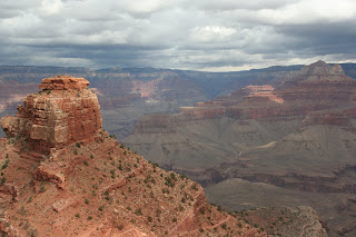
Grand Canyon National Park, AZ est. 1919

(Click here for a video of his comments.)

Keeping with Burns's signature approach, "America's Best Idea" is told from the bottom-up - oral history style - by ordinary folks from all backgrounds - rich and poor, black and white, yellow and brown, educated and illiterate - who were influential in creating today's National Park system. (Teddy Roosevelt, often regarded as the father of the park system, gets only a brief mention in only one episode.) Burns's tale is a biography of American character and American landscape, and is sure to be a visual feast and a spectacular lesson in American history.


Rocky Mountain National Park, CO est. 1915

Piqued your interest? Mark your calendars for September 27th and watch the previews here.

Enjoy!

(Interested in getting a closer, more personal look at the series before the September 27th debut? Check out the calendar of events for information about promotions in your area.)


Wednesday, September 02, 2009

Up A River in Minnesota...


Boundary Waters Wilderness, MN (2009)

...With a canoe.

I just returned from the Boundary Waters Canoe Area Wilderness where we worked on portage trails for the week. Sort of like backpacking, only you have to carry the canoe over the portages - as well as your stuff and tools!

We entered the wilderness at trailhead 14: Little Indian Sioux River and traveled to Shell Lake where we were going to repair the landing on the Shell Lake side of the Upper Pauness/Shell portage. However, it was underwater, so we traveled on to Heritage Lake and set up camp on the northern end of the lake.

We worked for two days on the Heritage-Loon Lake portage, and then moved to East Loon Lake were we had the best campsite in the BWCAW (IMO) -- a sand beach, a world-class view to the north across this large lake, and plenty of room to spread out. Previous tenants had left some impressive "flintsone furniture" in front of the large firepit, and there were lots of trees to hang tarps and drying lines.

On our day off, Wednesday, we invaded Canada by traveling up Loon Lake through the Beatty portage to Lac LaCroix. We had heard there were petroglyphs along a cliff wall.

The petroglyphs turned out to be pictographs, faint red images below the high water line. They are thought to be less than 500 years old, and the iron oxide has weathered them to the point of being very hard to see. There is apparently another site on north Lac LaCroix with a Moose pictograph.


The last two days of the trip, we worked on the East Loon Lake/Slim Lake portage, getting really muddy and moving tons (and tons) of rock. We built a 25-foot causeway on a section of the portage where we sank calf-deep in mud (not fun when you are carrying a canoe!). We raised the trail tread and channelized the water to one side. The peat moss in this area was more than a foot deep.


We didn't get to see any moose, whose numbers in northern Minnesota are apparently on a rapid decline, but we saw loons, crawdads, a salamander, squirrels, crows, eagles and heard distant wolves.


I loved (and miss!) the group of cheerful and enthusiastic people we did the trip with -- hard workers everyone. I love going to the Boundary Waters -- it's very different from the mountains and canyons I frequent in the intermountain west. All that water. Loons. Minnesota accents. You betcha!